Even as the news cycle is now forgetting the major December–January 2015–2016 flooding down the Mississippi River, the recent disaster raises thought-provoking questions
From
Christmas 2015 to the end of January 2016, hundreds of thousands of people
along the Mississippi River from north of Cape Girardeau, Missouri down to New
Orleans suffered the worst flooding since the epic flood of
 |
| Spectacular drone footage at sunrise on New Year’s Day, 2016, of the Mississippi River at near-record height held back by the concrete floodwall at Cape Girardeau, Missouri. Credit: Oral R. Friend |
summer 1993—some
of the worst suffering along major and minor tributaries. Below are some
thought-provoking images, along with some thoughts they provoked about the
recent devastation…
Should January flooding be so surprising?
Much was made in the
media
about how unusual it was to have major flooding in winter instead of spring. Why?
Partly because water freezes in winter and is thus bound up in snow and ice
until melted by spring temperatures and partly because warmer air can hold more
moisture than cold air.
 |
Pacific, Missouri, looking north along 1st Street on Tuesday, Dec. 29, 2015.
Credit: J.B. Forbes /St. Louis Post-Dispatch via AP
|
Although less frequent, major January floods are not
unheard-of. Indeed, the monumental 1937 flood along the Ohio and Mississippi
rivers—a disaster well remembered by some people still living—struck in January
and February.
 |
The Great Easter 1913 Flood
burst
levees all down the
Mississippi River.
Credit: Alfred J. Henry,
The Floods of 1913, Bulletin Z
|
Moreover, in
January 1913—two months before the unprecedented Great Easter flood—many of the
same areas of the lower Ohio River and the Mississippi River were hammered by a flood
that, in some parts of Kentucky, were actually worse than what came in March.
As this
winter (2015–2016) has been, the winter of 1912–1913 was unusually warm. It was
especially warm and wet in January and March, with February having more typical
Midwest winter weather. Indeed, research by USDA meteorologist Brad Rippey presents evidence suggesting that winter 1912–1913 was likely in the midst of
a very long and strong El Niño weather pattern (“A
Tale of Three Niños,” Weekly Weather and Crop Bulletin, May 3, 1994, pages 10–11).
 |
The New Year’s 2016 flood also
wreaked
havoc all the way down the
Mississippi. Credit: ArcGIS
|
So far, the
current winter (2015–2016) in different parts of the nation seems to be following
all of NOAA’s predictions for an unusually strong El Niño (in northern Ohio, the winter has been warm and
dry—even in the 60s in December, and 20s to 50s in January with only an inch or
two of snow at a time).
Flooding
along the Ohio and Mississippi rivers has happened all seasons of the year.
Spring floods are most common—but note: the storm system that brought even the
Great Easter 1913 flood barely cleared the vernal equinox.
Was hammered infrastructure in designated
flood zones? Images
of nearly submerged interstate highways abounded on broadcasts and websites during the 2015–2016 flooding, as well as aerial footage and photographs of
 |
| Before/after images of Interstate 44 flooded in Valley Park, Missouri. Credit: AP Photo/Jeff Roberson and Google Earth |
half-drowned water purification and sewage treatment plants. To be sure, these
latter are often along rivers as they withdraw raw water and discharge treated
effluent into waterways, and so may be in designated flood zones. For the
highways, however, it would be illuminating to determine whether or not they
were in nominal flood zones.
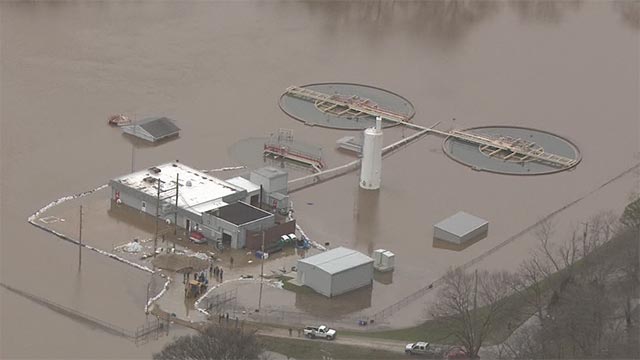 |
| The High Ridge Water Treatment Plant in Missouri was half-submerged in early January. Credit: KMOV-TV |
I would bet
money that many were not. That’s the
nature of major flooding: water goes where it is not supposed to. Flood maps
are outdated in ways that gravely underestimate actual risk, especially in
light of predicted and observed patterns of climate change—not only along
coastlines as a result of sea level rise, but also in the Midwest as a result
of intensifying rainfall and runoff.
 |
| NOAA’s October prediction for a strong El Niño precipitation and temperature pattern winter 2015–2016. |
This issue of
increasing risk has concerned hydrologists, insurers, and legislators for some
two decades, and has been the subject of innumerable reports by bodies ranging
from the U.S. Department of Homeland Security Office of Inspector General to the Union of Concerned Scientists. The recent flooding just demonstrates once more how catastrophic a 1913-scale
storm system could be if it recurred in the same geographical areas (see
“Benchmarking ‘Extreme’”).
Given that floodwater
can go where no one expects, a constant challenge to hydrologists, insurers,
and others remains: dissuading people from building where water is known to go
every now and then—to wit, floodplain. The name should be warning enough. But to
the unwary, floodplain can be insidiously attractive for its conveniently flat
topography, waterside views, fertile soil, and seemingly low enough risk. One
of the best slides I ever saw in a conference presentation was in a talk by
architect Adrienne Gann Schmetzer at the 2014 Stay Afloat conference in Indianapolis. It read simply: “DON’T BUILD ON FLOODPLAIN. The End.”
Can we trust in floodwalls and
levees? Today more
than a dozen cities along the Ohio and Mississippi rivers are protected by concrete
floodwalls and earthen levees, many built from the 1940s through 1960s by the
U.S. Army Corps of Engineers and now beautifully adorned with thousands of feet
of murals (see “Magnum Opus”).
 |
| Left: Top part of a mural on the concrete floodwall at Cape Girardeau at sunrise on New Year’s Day 2016, the day before the Mississippi River crested, photographed from a drone. Right: The same mural is shown as it looked in 2009 with the Mississippi at normal height; red arrow points to the approximate height of the 2016 flood at that point at the moment the drone flew by. Note the massive floodgate. Credit: Trudy E. Bell |
But more
than once in the course of a flood it has become evident that the pressure of
the floodwaters threatening an urban area is so great that the only apparent
alternative is to blow up a levee to relieve the pressure. Although that did
not happen in this most recent flood, it did five years earlier (2011) and many times before.
Moreover,
levees have collapsed on their own with the same effect. Crevasses opened many
places in the Mississippi River levee system in April 1913, in Beulah, Miss. and
along the Arkansas side. Levees collapsed suddenly in both Dayton,
Ohio and in Indianapolis on the Miami and White rivers. A levee protecting
Jeffersonville, Indiana, from the rising Ohio River was on the verge of
collapse and was saved only by fast concerted action of nearly 1,000 inmates
from the Indiana State Penitentiary (see “The Prisoners’ Feast”).
 |
Newspaper diagram of the
floodwaters
being held back by the 52-year-old
floodwall at Cape Girardeau
Credit:
Southeast Missourian
|
IMHO, the
most problematic aspect of levees and floodwalls is that their hulking
reassuring massive presence lulls people into thinking that living on
floodplain is safe. Dramatic footage from a drone flown at sunrise and at
sunset
over the floodwall at Cape Girardeau, Missouri, starkly reveals that
the Mississippi River rose to within only a few feet of the top of the
floodwall, around the second story of the shops and buildings across the
street. To me, a physics major my first two years of college, those images of human
habitation below the level of megatons of angry waters—plus this newspaper diagram
of the situation (left)—just give me the willies.
Plus
floodwalls can and do leak. As a result, huge pumps are used in Vicksburg
and Cape Girardeau to ensure that city streets stay dry—even when floodwaters stay high for weeks,
as happened in 1993.
 |
| Cape Girardeau floodwall from the land side. Four white arrows at far left indicate the crests of past floods at the city. The top one is for 1993, surpassed by nearly a foot on January 2, 2016.The 1913 flood is not shown. |
How did New Year’s flood compare to
1993 and 1913? Although
at Cape Girardeau the flood height bested the 1993 record by nearly a foot, the
recent flood rose and fell quickly compared to that long siege—so the overall
volume was lower. In some places, the intense rainfall of 10 to 14 inches in a
few days was comparable to the rainfall in 1913. But as horrific as the New
Year’s flood was, it was less widespread geographically. And thanks to modern measurement
and warning technologies—and, yes, even floodwalls—it claimed far fewer lives.
Next time: To Build a Tornado
6-Flood hit areas in Missouri. Photo:
Office of the Governor, Missouri