Showing posts with label Arkansas. Show all posts

Monday, February 1, 2016

Misery in Missouri...and Beyond


Even as the news cycle is now forgetting the major December–January 2015–2016 flooding down the Mississippi River, the recent disaster raises thought-provoking questions

From Christmas 2015 to the end of January 2016, hundreds of thousands of people along the Mississippi River from north of Cape Girardeau, Missouri down to New Orleans suffered the worst flooding since the epic flood of 

Spectacular drone footage at sunrise on New Year’s Day, 2016, of the Mississippi River at near-record height held back by the concrete floodwall at Cape Girardeau, Missouri. Credit: Oral R. Friend
summer 1993—some of the worst suffering along major and minor tributaries. Below are some thought-provoking images, along with some thoughts they provoked about the recent devastation…

Should January flooding be so surprising? Much was made in the media about how unusual it was to have major flooding in winter instead of spring. Why? Partly because water freezes in winter and is thus bound up in snow and ice until melted by spring temperatures and partly because warmer air can hold more moisture than cold air. 
Pacific, Missouri, looking north along 1st Street on Tuesday, Dec. 29, 2015. Credit: J.B. Forbes /St. Louis Post-Dispatch via AP
Although less frequent, major January floods are not unheard-of. Indeed, the monumental 1937 flood along the Ohio and Mississippi rivers—a disaster well remembered by some people still living—struck in January and February.

The Great Easter 1913 Flood
burst levees all down the 
Mississippi River. 
Credit: Alfred J. Henry,  
The Floods of 1913, Bulletin Z
Moreover, in January 1913—two months before the unprecedented Great Easter flood—many of the same areas of the lower Ohio River and the Mississippi River were hammered by a flood that, in some parts of Kentucky, were actually worse than what came in March.

As this winter (2015–2016) has been, the winter of 1912–1913 was unusually warm. It was especially warm and wet in January and March, with February having more typical Midwest winter weather. Indeed, research by USDA meteorologist Brad Rippey presents evidence suggesting that winter 1912–1913 was likely in the midst of a very long and strong El Niño weather pattern (“A Tale of Three Niños,” Weekly Weather and Crop Bulletin, May 3, 1994, pages 10–11).

The New Year’s 2016 flood also wreaked 
havoc all the way down the 
Mississippi. Credit: ArcGIS
So far, the current winter (2015–2016) in different parts of the nation seems to be following all of NOAA’s predictions for an unusually strong El Niño (in northern Ohio, the winter has been warm and dry—even in the 60s in December, and 20s to 50s in January with only an inch or two of snow at a time).

Flooding along the Ohio and Mississippi rivers has happened all seasons of the year. Spring floods are most common—but note: the storm system that brought even the Great Easter 1913 flood barely cleared the vernal equinox. 

Was hammered infrastructure in designated flood zones? Images of nearly submerged interstate highways abounded on broadcasts and websites during the 2015–2016 flooding, as well as aerial footage and photographs of 
Before/after images of Interstate 44 flooded in Valley Park, Missouri. Credit: AP Photo/Jeff Roberson and Google Earth
half-drowned water purification and sewage treatment plants. To be sure, these latter are often along rivers as they withdraw raw water and discharge treated effluent into waterways, and so may be in designated flood zones. For the highways, however, it would be illuminating to determine whether or not they were in nominal flood zones. 
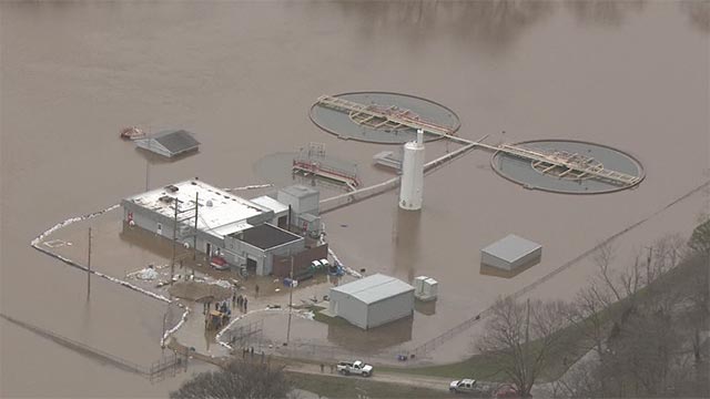
The High Ridge Water Treatment Plant in Missouri was half-submerged in early January. Credit: KMOV-TV
I would bet money that many were not.  That’s the nature of major flooding: water goes where it is not supposed to. Flood maps are outdated in ways that gravely underestimate actual risk, especially in light of predicted and observed patterns of climate change—not only along coastlines as a result of sea level rise, but also in the Midwest as a result of intensifying rainfall and runoff. 

NOAA’s October prediction for a strong El Niño precipitation and temperature pattern winter 2015–2016.
This issue of increasing risk has concerned hydrologists, insurers, and legislators for some two decades, and has been the subject of innumerable reports by bodies ranging from the U.S. Department of Homeland Security Office of Inspector General to the Union of Concerned Scientists. The recent flooding just demonstrates once more how catastrophic a 1913-scale storm system could be if it recurred in the same geographical areas (see “Benchmarking ‘Extreme’).

Given that floodwater can go where no one expects, a constant challenge to hydrologists, insurers, and others remains: dissuading people from building where water is known to go every now and then—to wit, floodplain. The name should be warning enough. But to the unwary, floodplain can be insidiously attractive for its conveniently flat topography, waterside views, fertile soil, and seemingly low enough risk. One of the best slides I ever saw in a conference presentation was in a talk by architect Adrienne Gann Schmetzer at the 2014 Stay Afloat conference in Indianapolis. It read simply: “DON’T BUILD ON FLOODPLAIN. The End.”

Can we trust in floodwalls and levees? Today more than a dozen cities along the Ohio and Mississippi rivers are protected by concrete floodwalls and earthen levees, many built from the 1940s through 1960s by the U.S. Army Corps of Engineers and now beautifully adorned with thousands of feet of murals (see “Magnum Opus”). 
Left: Top part of a mural on the concrete floodwall at Cape Girardeau at sunrise on New Year’s Day 2016, the day before the Mississippi River crested, photographed from a drone. Right: The same mural is shown as it looked in 2009 with the Mississippi at normal height; red arrow points to the approximate height of the 2016 flood at that point at the moment the drone flew by. Note the massive floodgate. Credit: Trudy E. Bell
But more than once in the course of a flood it has become evident that the pressure of the floodwaters threatening an urban area is so great that the only apparent alternative is to blow up a levee to relieve the pressure. Although that did not happen in this most recent flood, it did five years earlier (2011) and many times before. 

Moreover, levees have collapsed on their own with the same effect. Crevasses opened many places in the Mississippi River levee system in April 1913, in Beulah, Miss. and along the Arkansas side. Levees collapsed suddenly in both Dayton, Ohio and in Indianapolis on the Miami and White rivers. A levee protecting Jeffersonville, Indiana, from the rising Ohio River was on the verge of collapse and was saved only by fast concerted action of nearly 1,000 inmates from the Indiana State Penitentiary (see “The Prisoners’ Feast”).

Newspaper diagram of the floodwaters
being held back by the 52-year-old 
floodwall at Cape Girardeau
IMHO, the most problematic aspect of levees and floodwalls is that their hulking reassuring massive presence lulls people into thinking that living on floodplain is safe. Dramatic footage from a drone flown at sunrise and at sunset over the floodwall at Cape Girardeau, Missouri, starkly reveals that the Mississippi River rose to within only a few feet of the top of the floodwall, around the second story of the shops and buildings across the street. To me, a physics major my first two years of college, those images of human habitation below the level of megatons of angry waters—plus this newspaper diagram of the situation (left)—just give me the willies.

Plus floodwalls can and do leak. As a result, huge pumps are used in Vicksburg and Cape Girardeau to ensure that city streets stay dry—even when floodwaters stay high for weeks, as happened in 1993.

Cape Girardeau floodwall from the land side. Four white arrows at far left indicate the crests of past floods at the city. The top one is for 1993, surpassed by nearly a foot on January 2, 2016.The 1913 flood is not shown.
How did New Year’s flood compare to 1993 and 1913? Although at Cape Girardeau the flood height bested the 1993 record by nearly a foot, the recent flood rose and fell quickly compared to that long siege—so the overall volume was lower. In some places, the intense rainfall of 10 to 14 inches in a few days was comparable to the rainfall in 1913. But as horrific as the New Year’s flood was, it was less widespread geographically. And thanks to modern measurement and warning technologies—and, yes, even floodwalls—it claimed far fewer lives.

Next time: To Build a Tornado 

6-Flood hit areas in Missouri. Photo: Office of the Governor, Missouri  


Monday, June 1, 2015

Prayers and Lessons


The massive multistate flooding in the southern plains states in late May 2015 actually approaches the magnitude of the multistate Great Easter 1913 Flood in some ways. Message: Extreme, widespread, non-hurricane rain events in the middle of the nation can happen again. Are we ready?

The epic flooding across Texas still ongoing strikes personal alarm in my heart: my sister and nephew live in a suburb of Dallas. 

Flash floods can be as damaging as tornadoes, as evidenced by the smashed ruins of a home on the Blanco River after heavy rains caused flash flooding in Wimberley, Texas, May 24, 2015. Credit: Rodolfo Gonzalez/AP

But just because Houston, Dallas, Austin, Corpus Christi, Brownsville, and other Texas major metropolitan areas have riveted the public eye, let us not forget that also hammered were Oklahoma (my sister’s in-laws live near Oklahoma City), Louisiana, Arkansas, Missouri—and even Kansas and Nebraska. Yet, just in the way the news focuses on Texas, one can see the forgetting is already setting in.
Radar mosaic of storm system marching across Texas and Oklahoma, May 24, 2015, causing multistate flooding. Credit: National Weather Service 
In fact, I’m willing to wager that this 2015 multistate natural disaster will be remembered as something like the Great Texas Flood, or worse, the Great Houston Flood—thereby diminishing its significance to history—instead of with a name befitting its scale, such as, say, the Great Memorial Day 2015 Flood. And with a diminished name comes forgetting. After all, we’ve seen it all before: in what has been handed down to us with a name diminished to be one city’s flood—the Great Dayton Flood—instead of the Great Easter 1913 Flood, so vast that it engulfed more than a quarter of the nation, and yet has been virtually forgotten.  
Left: Rescue personnel grab the hand of a man stranded in rushing water at the northwest corner of Lamar Blvd. and 15th St. in Austin, Texas. Shoal Creek overflowed its banks and inundated the major traffic artery with rushing water. Several cars were stalled under and near the 15th St. Bridge on Monday, May 25, 2015. Credit: Alberto Martinez/Austin American-Statesman via AP 
Right: After floodwaters had receded perhaps six feet at Burns Avenue and Catherine Street south of downtown Dayton, Ohio, stranded people could be rescued in one of the National Cash Register flat-bottomed boats. Note the dark staining on the sides of the brick buildings showing peak flood height. Credit: Dayton Metro Library
Despite differences in the regions and eras, the tragedy playing out in the southern plains states right now bears such striking parallels to what happened across the Midwestern, eastern, and northern plains states a century ago that a few comparisons are instructional. Moreover, the comparisons point up two additional, chilling cautionary messages for our future.

Side by side
Below are selected photographs of the severe flooding across the southern plains states in 2015, paired with similar photos from various states from the Great Easter 1913 flood. For all images, all rights remain with the original photographers and news organizations credited in the captions.
Incredible lightning strike seen in Kyle, Texas, on Monday, May 25, 2015. Credit: Twitter/@marteenee13 and @WarrenHughes13
First striking parallel: the storm system itself. In neither case was the flooding due to a hurricane or storm surge. In both cases, flooding was due to long-duration, intense rainfall from a monumental, slow-moving storm system featuring repeated lows following one right after another, concentrated over a region already saturated from previous intense rainfall so runoff was exceptionally high (for 1913, see “Be Very Afraid”; for 2015 see Weather. com). In both cases, the storm was accompanied by violent lightning (see image 4 at here) and tornadoes (for 1913 see “’My Conception of Hell’” and “Terror at Terre Haute”; for 2015 see Wikipedia.
Left: Woman climbing through the ruins of her tornado destroyed house in Oklahoma. Credit: NBC News. Right: Woman surveys ruins of a home destroyed by the Great Easter 1913 Omaha tornado. Credit: Omaha Public Library 
In both cases, rivers rose rapidly and descended on communities as veritable walls of water, even in regions not normally prone to flooding. Such flash flooding has the violence of tornadoes (see "An Unnecessary Tragedy").
Left: The level of the Blanco River at Wimberley soared from 5 feet on Saturday afternoon, May 23, to a record 40.21 feet at 1:01 am CDT Sunday, more than 7 feet above the prior record. The river gauge stopped reporting after this point. Credit: NWS Advanced Hydrologic Prediction Service. Right: The fast-rising Muskingum River at Zanesville, Ohio, in 1913 also wiped out the weather gauges, and also crested at nearly 52 feet (vertical line in the middle of the chart) – 15 feet higher than a previous record set by a flood 20 years earlier. Credit: NWS 
But here’s a big difference between the two storm systems. Communications still functioned in 2015 and warnings were issued and heeded, so “only” 28 lives were lost—actually, likely 28 and counting as more bodies turn up and as people injured during the violence of flash flooding perish from complications of their injuries. In 1913, the death count—over 600 in Ohio and Indiana alone—was much higher because the massive windstorm on Good Friday, March 21 severely crippled communications so that weather data could not be gathered nor warnings issued (see “The First Punch”). Moreover, some of the flash flooding occurred in the dark of night, sweeping away people in their homes with no warning (see “’Death Rode Ruthless…’”).
Left: In this aerial photo, water from the Arkansas River floods a farm shed in Faulkner County near Conway, Ark., Friday, May 29, 2015. Credit: Danny Johnston/AP.  Right: Dayton homes were submerged to their eaves in the Great Easter 1913 Flood. Credit: Dayton Metro
In both calamities, homes and buildings drowned, the floodwaters reaching midway up the first story or even to the eaves. Note the sheen of oil on the floodwaters surrounding the half-submerged farm building photographed in 2015. That points out a serious hazard of severe floods today—the fact that they can breach stores of chemicals and toxic waste dumps, so the chemical-laden floodwaters are themselves toxic (see “Benchmarking 'Extreme'”) Indeed, in Houston, 100,000 gallons of untreated wastewater and raw sewage spilled into the floodwaters when the Southwest Wastewater Treatment Plant was flooded. But perhaps that was no different than conditions during the 1913 flood when the human excrement from the vaults of thousands of outdoor privies (outhouses) contaminated the floodwaters.
More than 100,000 gallons of untreated wastewater has spilled after Houston's Southwest Wastewater Treatment Plant flooded Tuesday when a bayou overflowed its banks. Credit: Before It’s New
By the way, don’t be surprised if the flooding in the southern plains states also causes fires due to electrical shorts and broken gas mains—it happened in Dayton, Ohio, and Troy, New York, in 1913 and also after Hurricane Katrina in 2005 (see “Like a War Zone”) .
Left: Flooding in Norman, Oklahoma, on Saturday, May 23, 2015. Credit: StevenAnderson. Right: 1913 flooding photographed in Hamilton, Ohio. Credit: Michael J. Colligan History Project
In both 2015 and 1913, flooding brought transportation to a standstill, by flooding roads and streets, stranding vehicles, and destroying bridges. In 1913, railroads were also crippled as sections of track were washed away.
Floodwaters in May 2015 swept away an entire bridge in Wimberley, Texas. Credit: Twitter/@bez2012 Fifth Street Bridge over the Great Miami River in Dayton was completely destroyed in by the Great Easter 1913 Flood. Credit: Miami Conservancy District.
Altogether, rainfall for May 2015 in Oklahoma and Texas blasted through previous records, with totals exceeding two feet in that single month in Norman and between 18 to 24 inches widespread elsewhere. For perspective, that approaches triple the average winter monthly rainfall in Olympia, Washington, in the Pacific Northwest rain forest (about 8 inches per month). Indeed, in Houston and elsewhere, rain fell at a rate of more than 4 inches per day. A few places received rain at a rate of up to four inches per hour for short stints.

Some wag at the Fort Worth National Weather Service calculated that the rain that fell on Texas during the month of May amounted to more than 35 trillion gallons, enough to cover the entire state 8 inches deep. 

For comparison, in 1913, W. J. Cox, head of the Pittsburgh weather bureau, calculated that an average of 6.26 inches inundated the combined area of Ohio and Indiana in just four days  , amounting to close to 1.1 trillion cubic feet; at 7.48 gallons per cubic foot, that would come to about 8.2 trillion gallons. 

Actually, two years ago, Sarah Jamison, senior hydrologist at the Cleveland National Weather Service, recalculated that that 8 trillion gallons was runoff, produced by closer to 12 trillion gallons of actual rainfall. Yes, 12 trillion gallons is only a third of 35+ trillion gallons, but Ohio and Indiana together also have less than a third of Texas’s area (1/3.6 to be exact). More importantly: the 1913 calculations are for just four days, whereas the Texas ones are for the entire month. A more direct comparison would be the intensest four-day period over the southern plains states. And of course, for full storm volume, one really needs to add in the rainfall totals over all the other states deluged in both floods.

Two chilling cautionary messages
Still, at first glance, the rainfall totals point up an astounding revelation: the Great Memorial Day 2015 flood in the southern plains states likely approaches the magnitude of the Great Easter 1913 Flood for both intensity and multistate  
Left: May 2015 shattered rainfall records across both Texas and Oklahoma for the entire month of May—over 2 feet in some places. Credit: Weather. com  Right: modern reconstruction of rainfall across Indiana and Ohio for just "flood week" March 23–28, 1913. Credit: Midwest Regional Climate Center 
area—especially monumental as both natural disasters were due to rainfall alone, not to a hurricane (the heaviest rainfall ever in the U.S. was 43 inches in 24 hours, also in Texas, but during a hurricane).

The Great Memorial Day Flood of 2015 was a multistate event comparable in certain ways to the Great Easter Flood of 1913. Here they are shown side by side roughly to scale. Each deluge exceeded the other in some ways, but both were notable in being extreme non-hurricane rain events. Southern plains states map: USA Today; U.S. map with 1913 contours and tornadoes: ©2008 Trudy E. Bell
Let’s explore this 2015-1913 comparison a little further. In the southern plains, four inches per day comes to a foot in three or four days, comparable to the 11+ inches in four days in the most intense part of the 1913 flood over Ohio’s continental divide. Texas’s and Oklahoma’s overall monthly rainfall far exceeded any monthly total Ohio has ever experienced. 

In short, had the southern plains rain fallen over the same wide geography as the Great Easter 1913 Flood centered on Ohio’s continental divide, no question it would have precipitated a comparable repeat of that disaster. That is relevant because several recent (2012–2014) reports have cautioned that intense rain events are likely to increase both locally and regionally (see “Benchmarking 'Extreme'”).
In both floods, human beings were not the only victims. In 1913, thousands of horses, cattle, other livestock, and countless wildlife succumbed. In 2015, livestock, deer and alligators are in danger (see Click2Houston and the above Reuters video) while scores of pet animals are separated from their owners.
Moreover, if 1913 is any guide for today, recovery will be a long, tough slog. Texas, Oklahoma, Arkansas, Louisiana, Kansas, and elsewhere will not return back to normal as soon as the waters recede. The severe damage to infrastructure and homes will require months, if not years, for recovery. 

Moreover, today as in 1913, most people do not have flood insurance: normal homeowners’ policies do NOT insure against flood or groundwater. Flood insurance is required only in those areas designated as flood zones. As many 
8 Left: Rising floodwaters at Shoal Creek are shown after days of heavy rain on May 25, 2015 in Austin, Texas. Credit: Drew Anthony Smith/Getty Images. Right: Water rushing against the arches of the Court Street Bridge in Rochester, New York, in March 1913. Credit: Monovisions 
areas in Texas and Oklahoma that flooded were not in designated flood zones, most of those residents likely did not have policies. In other words, the destruction of their homes and all their contents and life's savings is a dead loss. 

Last: one unpleasant surprise from 1913 was: areas flooded that were not supposed to flood. The lesson from 2015 for the future is: how true that still can be.
My fervent thoughts and prayers go out to all the flood sufferers, with hopes that aid pours into them as it did to those in 1913.

©2015 Trudy E. Bell

Next time: Never Before Seen

Selected References
For discussion about the 1913 flood losses being especially severe because areas flooded that were not normally prone to flooding, see A. H. Horton and H. J. Jackson, The Ohio Valley Flood of March–April 1913, Water Supply Paper 334, U.S. Geological Survey, Government Printing Office, Washington, D.C., 1918, especially pages 45 and 85.
Bell, Trudy E., The Great Dayton Flood of 1913, Arcadia Publishing, 2008. Picture book of nearly 200 images of the flood in Dayton, rescue efforts, recovery, and the construction of the Miami Conservancy District dry dams for flood control, including several pictures of Cox. (Author’s shameless marketing plug: Copies are available directly from me for the cover price of $21.99 plus $4.00 shipping, complete with inscription of your choice; for details, e-mail me), or order from the publisher.